
Hurricane Lowell: 5 Hawaii Risks Revealed
Hurricane Lowell is raising concerns across Hawaii as the powerful Pacific storm approaches the island chain, with forecasters warning that dangerous surf, heavy rain and strong winds could affect the islands even if the hurricane’s center remains offshore.
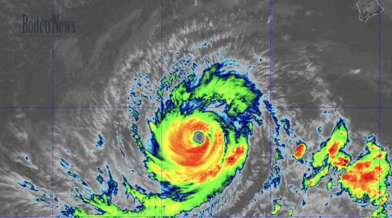
The storm has become the focus of increasing attention as its forecast track brings it closer to the western Hawaiian Islands. The National Weather Service in Honolulu said Lowell is expected to pass west of Kauai’s coastal waters, while significant impacts could extend hundreds of miles from the hurricane’s center.
The latest forecasts show that the most important question is no longer simply whether Hurricane Lowell will make landfall. Instead, forecasters are watching how close the storm comes to the islands and how its large circulation interacts with Hawaii’s coastline.
That distinction matters because a hurricane does not need to make a direct landfall to produce dangerous conditions.
Large swells can reach shore well ahead of the storm’s center. Heavy rainfall can trigger flooding far from the eye, while strong winds can affect exposed areas depending on the storm’s exact track.
For residents and visitors in Hawaii, the next several days will therefore be critical.
Hurricane Lowell Is Closing In on Hawaii
Hurricane Lowell has maintained major-hurricane strength while moving through the central Pacific.
The National Weather Service’s latest Hawaii forecast discussion said Lowell was positioned roughly 620 statute miles southwest of Kauai and was moving west-northwest. Forecasters expected the hurricane to turn northward and make its closest approach to the main Hawaiian Islands around Monday night.
The forecast track at that time placed Lowell west of Kauai’s coastal waters. However, forecasters emphasized that the storm could still produce several significant hazards across Hawaii.
The projected impacts include high surf, heavy rainfall, strong winds and the possibility of flash flooding.
That means Hawaii residents should not judge the threat solely by whether the center of Lowell crosses land.
A storm’s outer bands and wind field can extend well beyond its eye. In addition, ocean swells generated by a powerful hurricane can travel considerable distances before reaching shore.
The National Hurricane Center has specifically warned that swells from Lowell could produce life-threatening surf and dangerous rip-current conditions in portions of the Hawaiian Islands.
1. Dangerous Surf Could Be the First Major Threat
One of the most immediate concerns associated with Hurricane Lowell is the ocean.
Large swells generated by a powerful hurricane can reach Hawaii even when the storm’s center remains hundreds of miles offshore. Those waves can produce powerful breaking surf and dangerous currents that are especially hazardous for swimmers, surfers and inexperienced beachgoers.
The National Hurricane Center has warned that Lowell-generated swells could create life-threatening surf and rip currents around parts of the Hawaiian Islands.
This is particularly important because dangerous surf can affect beaches that appear relatively calm from shore.
Rip currents can pull swimmers away from the coastline with tremendous force. Even experienced swimmers can struggle when powerful ocean swells combine with strong currents and breaking waves.
Visitors may also underestimate the danger because a beach may not be experiencing rain or strong winds when the surf becomes hazardous.
For that reason, people near the coast should pay close attention to local beach warnings and conditions rather than relying on the appearance of the weather overhead.
Swimming, surfing, snorkeling and boating conditions can deteriorate before the center of a hurricane approaches.
Internal link opportunity: Add a link here to your existing article about Hawaii beach safety, rip currents or hurricane preparedness.
2. Heavy Rain Could Trigger Flash Flooding
Rain is another major concern as Hurricane Lowell approaches Hawaii.
According to the National Weather Service, heavy rainfall associated with Lowell could affect areas well away from the storm’s center. Forecasters specifically identified flash flooding as one of the primary hazards expected across the state.
Hawaii’s mountainous terrain can make intense rainfall particularly dangerous.
When tropical moisture reaches the islands, rain can become concentrated over mountains and windward areas. Streams and drainage channels can rise rapidly, while roads can become hazardous within a short period.
Flooding can also occur in areas that are not directly exposed to hurricane-force winds.
That is why residents should monitor rainfall forecasts separately from the hurricane track. A forecast showing the storm center remaining offshore does not automatically mean every community will avoid dangerous weather.
The National Weather Service said weather conditions are expected to deteriorate beginning Sunday evening and continuing into the following week as Lowell approaches from the southwest.
People living in flood-prone locations should be prepared to move to safer areas if local officials issue evacuation or flood-related instructions.
Drivers should also avoid entering flooded roads. Water can conceal washed-out pavement, debris or deep channels, making seemingly passable roads extremely dangerous.
3. Strong Winds Remain a Serious Concern
Wind is another major risk associated with Hurricane Lowell.
Although the forecast track has generally kept the hurricane’s center west of Kauai, the storm’s size and strength mean that strong winds can still affect portions of Hawaii.
The National Weather Service has described Lowell as a major hurricane and warned that strong winds are among the hazards Hawaii could experience.
The strongest winds will depend heavily on Lowell’s final track.
A small shift in the storm’s path could change which islands experience the strongest conditions. Mountainous terrain can also accelerate or redirect winds in some areas.
Residents should therefore secure loose outdoor objects before conditions deteriorate.
Items such as patio furniture, outdoor decorations, trash containers and lightweight equipment can become dangerous projectiles during strong winds.
Residents should also be prepared for potential power interruptions. Even if the hurricane’s core stays offshore, strong winds and heavy rain can cause trees or branches to fall onto power lines.
The safest approach is to complete preparations before tropical-storm conditions arrive.
4. Kauai and Niihau Are Receiving Particular Attention
The western Hawaiian Islands are especially important in the current Hurricane Lowell forecast.
Kauai and Niihau are positioned closest to the projected path, although the exact track can still change. The National Weather Service has indicated that Lowell is expected to pass west of Kauai’s coastal waters while maintaining major-hurricane strength.
That does not mean the rest of Hawaii can ignore the storm.
Lowell’s impacts could spread across a much broader area. High surf and heavy rain can reach locations far from the hurricane’s center, while changes in wind direction may affect different sides of the islands.
The National Weather Service has emphasized that impacts such as high surf and heavy rain could extend hundreds of miles from the center of the hurricane.
Residents should therefore focus on local forecasts rather than assuming that a single statewide hurricane track tells the entire story.
For Kauai and Niihau in particular, residents should remain alert to official warnings and be prepared for changes in the forecast.
5. The Forecast Could Still Change
Perhaps the most important point about Hurricane Lowell is that the situation remains dynamic.
Tropical cyclone forecasts become more reliable as a storm gets closer to its potential impact area, but small changes in steering currents can still alter the eventual path.
The National Weather Service has continued to monitor Lowell’s expected turn toward the north and its subsequent approach to Hawaii.
This is one reason residents should avoid relying on a single forecast graphic posted hours earlier.
The storm’s position, intensity and movement are continuously reassessed using satellite data, aircraft observations, weather stations and computer forecast models.
NOAA satellite imagery is providing ongoing observations of Lowell as it moves across the Pacific.
For the public, the practical lesson is straightforward: prepare for the current forecast, but remain ready to adjust plans if the forecast changes.
Why a Direct Hit Is Not the Only Concern
Hurricane Lowell demonstrates why hurricane preparation cannot focus exclusively on landfall.
A hurricane’s strongest winds are concentrated around its inner circulation, but its overall weather system can be enormous.
Ocean swells may arrive before the storm’s strongest winds. Rain bands can produce flooding in areas far from the eye. Wind gusts can also extend outward and affect exposed locations.
In Hawaii, geography adds another layer of complexity.
The islands’ mountains can influence rainfall and wind patterns, creating sharply different conditions across relatively short distances.
As a result, one part of an island could experience heavy rain while another sees much lighter conditions.
This makes local National Weather Service forecasts particularly important during the approach of Hurricane Lowell.
Hawaii Residents Should Prepare Before Conditions Worsen
Residents do not need to wait for the final track to become perfectly clear before preparing.
Basic hurricane preparations should be completed while conditions remain manageable.
That includes securing outdoor objects, checking emergency supplies, charging phones and other essential devices, reviewing evacuation information and monitoring official weather updates.
Households should also have enough essential supplies to remain self-sufficient if roads become difficult to travel or power is interrupted.
People near streams, low-lying areas or other flood-prone locations should know where they would go if authorities recommend moving to higher ground.
Drivers should avoid unnecessary travel once heavy rain and strong winds begin.
For visitors, the safest choice may be to follow instructions from hotels, local authorities and emergency officials rather than attempting to continue normal recreational activities.
Most importantly, people should stay away from dangerous surf when authorities issue warnings.
Hurricane Lowell Comes During an Unusual Pacific Pattern
Lowell is also part of an unusually active period across the Pacific.
Multiple hurricanes have been active at the same time, creating a striking concentration of tropical activity. Recent reports have highlighted Lowell alongside Hurricanes Karina and Marie in the Pacific.
For Hawaii, however, Lowell is the storm receiving the greatest attention because of its proximity to the islands.
The storm’s track toward the western portion of Hawaii is being closely monitored by forecasters as the system approaches.
The situation also illustrates the difference between storm intensity and actual local impacts.
A powerful hurricane can weaken before reaching an island and still create dangerous conditions through rain, surf and wind.
Conversely, a storm that remains offshore can still produce significant coastal hazards.
What Happens Next?
The next phase of Hurricane Lowell’s approach will depend on its track and how quickly its intensity changes.
The National Weather Service expects Lowell to make its closest approach to the main Hawaiian Islands around Monday night, with the storm forecast to pass west of Kauai’s coastal waters.
Even under that scenario, officials expect potentially significant weather across Hawaii.
The biggest concerns include high surf, heavy rain, flash flooding and strong winds.
Because the storm’s impacts can extend beyond its center, residents across the islands should continue monitoring updates rather than assuming they are outside the danger zone.
Forecasts can change, especially as Lowell interacts with surrounding weather systems.
NBC News — Hurricane Lowell and Hawaii
National Hurricane Center — Hurricane Lowell advisories
National Weather Service Honolulu
Final Takeaway
Hurricane Lowell is a serious and evolving threat to Hawaii, even if the storm’s center remains offshore.
The greatest immediate concerns include dangerous surf and rip currents, followed by heavy rainfall, flash flooding and strong winds. Kauai and Niihau are receiving particular attention because of their proximity to Lowell’s projected path, but impacts could extend across a much wider portion of the Hawaiian Islands.
The best response is preparation and vigilance.
Residents should secure their homes, review emergency plans and monitor official forecasts. Visitors should avoid dangerous ocean conditions and follow instructions from local authorities.
Most importantly, people should remember that Hurricane Lowell does not need to make a direct landfall to create life-threatening conditions in Hawaii.
As the storm approaches, the forecast will continue to evolve. The latest information from the National Hurricane Center and National Weather Service should remain the primary guide for decisions about travel, evacuation and safety.