Winter Weather Forecast: 5 Shocking 2026–2027 Predictions
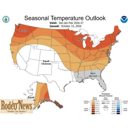
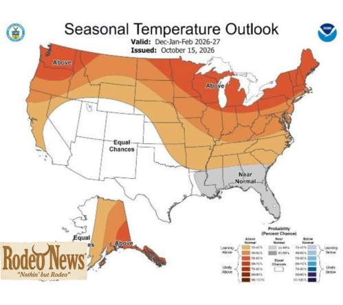
The winter weather forecast for 2026–2027 points toward an unusually warm and potentially stormy season across much of the United States, with a powerful El Niño expected to influence temperatures, precipitation and snowfall patterns. Federal forecasters say northern states are likely to experience warmer-than-average conditions, while much of the South could see increased precipitation between December 2026 and February 2027.
The outlook, released by the National Oceanic and Atmospheric Administration (NOAA) on October 15, offers an early look at what Americans might experience during the upcoming winter. Although the forecast does not guarantee specific weather conditions on individual days, it identifies broad regional patterns that could influence winter travel, agriculture, water supplies and holiday plans.
One of the most notable findings is the potential contrast between the northern and southern United States. While warmer conditions could reduce opportunities for widespread snowfall in some northern areas, wetter weather could bring more storms to parts of the South and East.
The developing El Niño is expected to play a central role in these patterns. This natural climate phenomenon changes ocean temperatures in the tropical Pacific and influences atmospheric circulation around the world.
However, a warmer seasonal outlook does not mean winter will disappear. Cold snaps, snowstorms and dangerous weather remain possible even in areas expected to experience above-average temperatures.
Here are five important takeaways from the latest winter weather forecast.
1. Winter Weather Forecast Predicts Warmer Conditions Across the North
The first major finding in NOAA’s winter outlook is the increased likelihood of above-average temperatures across much of the northern United States.
The agency expects warmer-than-normal conditions across the northern tier of the country, with elevated temperatures also favored in several other regions.
Parts of the Pacific Northwest, northern California, the Midwest, the Mississippi Valley and areas of the eastern United States are among the locations where warmer conditions are favored in NOAA’s broader seasonal outlooks.
These patterns could influence how winter feels in communities that traditionally experience prolonged periods of freezing temperatures.
Residents may encounter more days with temperatures above their historical seasonal averages. Snow cover could also become less persistent in some areas if warmer temperatures cause snowfall to melt more quickly.
Nevertheless, seasonal averages do not describe every day of the winter.
A region expected to experience above-average temperatures can still experience severe cold outbreaks. Individual storms may also bring heavy snowfall when temperatures and atmospheric conditions align.
For that reason, the winter weather forecast should be interpreted as a guide to overall seasonal probabilities rather than a prediction that cold weather will be absent.
What warmer winter conditions could mean
Warmer temperatures could affect several aspects of daily life.
Homeowners might experience changes in heating demand, while transportation agencies could face a different mix of winter weather hazards. Farmers may also need to consider how temperature fluctuations influence soil conditions, crop development and seasonal planning.
However, warmer weather does not necessarily eliminate winter risks. Rain falling on frozen ground, sudden temperature drops and rapidly changing conditions can still create hazardous travel.
The practical lesson is that residents should continue monitoring local forecasts even if their region is expected to experience a milder winter overall.
2. A Strong El Niño Could Reshape the Winter Weather Forecast
El Niño is expected to be one of the most important influences on the 2026–2027 winter season.
The phenomenon develops when sea surface temperatures in parts of the central and eastern equatorial Pacific become warmer than normal. These changes affect atmospheric circulation and can alter the position and behavior of the jet stream.
The jet stream is a fast-moving current of air that helps steer weather systems across North America. Changes in its position can influence where storms travel, which regions receive precipitation and where warmer or colder air becomes established.
According to NOAA’s October 15 outlook, a very strong El Niño is expected to influence winter conditions across the United States.
Ken Graham, director of the National Weather Service, said the phenomenon is likely to shift the jet stream southward and eastward, favoring stormier conditions across the South.
That pattern could produce a different winter experience depending on where people live.
Some areas may experience frequent rainfall, while others could see fewer opportunities for substantial snowfall. Regional outcomes will depend on the interaction between El Niño and other atmospheric conditions.
Why El Niño matters
El Niño is a recurring climate pattern, not a storm that moves across the country.
Its influence develops over months and can affect weather patterns across large geographic areas. Strong events can create recognizable seasonal tendencies, although the precise effects vary from one winter to another.
For example, El Niño can influence the storm track across the southern United States. It may also affect temperature patterns in the northern states.
However, El Niño alone cannot determine whether a particular city will experience a white Christmas, a major snowstorm or an extended cold spell.
Other climate patterns, atmospheric disturbances and local weather conditions also play important roles.
Consequently, the latest winter weather forecast provides a useful starting point for understanding seasonal risks, but shorter-range forecasts will remain essential as winter approaches.
3. The Southern United States Could See a Wetter Winter
Another important part of the winter outlook is the increased likelihood of wetter-than-average conditions across much of the southern United States.
NOAA’s October 15 announcement indicates that wetter conditions are favored across the southern tier, stretching from California toward Florida, as well as along the Eastern Seaboard.
This broad pattern could bring additional precipitation to areas that depend on winter rainfall to replenish reservoirs, support agriculture and improve drought conditions.
However, more precipitation can also create challenges.
Heavy rainfall may overwhelm drainage systems, cause localized flooding and disrupt transportation. Communities that experience repeated storms could face saturated soils and rising water levels in vulnerable areas.
The impact will depend on how much rain falls, how quickly it arrives and whether local ground conditions can absorb the additional moisture.
California and the Southwest
Parts of California and the Southwest could benefit from additional precipitation, particularly where drought has affected water supplies and agricultural operations.
Winter storms can contribute to reservoir inflows and mountain snowpack, which are important sources of water in many western communities.
Yet the benefits are not automatic.
Intense rainfall can increase flood risks, particularly in areas with steep terrain, burn scars or inadequate drainage. Atmospheric river events can also deliver large amounts of moisture over relatively short periods.
The distinction between beneficial rainfall and hazardous precipitation will depend on storm intensity, timing and local conditions.
The Southeast and Eastern Seaboard
The Southeast could also experience wetter-than-average conditions during the forecast period.
Rainfall may help replenish soil moisture and water supplies. At the same time, repeated storms could disrupt outdoor activities, transportation and agricultural operations.
Residents should pay attention to flood watches, severe weather alerts and local emergency guidance when significant storms are forecast.
Importantly, a wetter seasonal outlook does not mean every location will experience above-average rainfall. NOAA’s outlook identifies areas where probabilities favor wetter conditions, not a guaranteed outcome for every community.
4. The Snowfall Forecast Could Disappoint Northern Snow Lovers
For people hoping for a snowy winter, the latest outlook presents a complicated picture.
Although NOAA forecasts seasonal temperature and precipitation patterns, it does not issue a nationwide seasonal snowfall prediction as part of this outlook.
Meteorologists nevertheless expect the influence of El Niño to shift snowfall opportunities toward some southern regions rather than favoring the northern United States.
The Southern Rockies and parts of the Southwest and Southeast may have better chances of above-average snowfall under the anticipated pattern.
Meanwhile, much of the northern United States, including portions of the Northeast, Great Lakes, Upper Midwest and Northern Rockies, could experience below-normal snowfall.
This does not mean those regions will be snow-free.
Individual winter storms can still produce heavy snow, particularly when cold air meets a strong weather system. The seasonal outlook simply suggests that the overall pattern may be less favorable for sustained or widespread snowfall in certain northern areas.
Will major cities see less snow?
Cities in the Northeast and Great Lakes region could face a winter with fewer opportunities for substantial snowfall than residents might expect from historical averages.
However, the outlook does not establish exactly how much snow any individual city will receive.
Snowfall depends on several factors, including storm tracks, temperatures in the atmosphere, moisture availability and the timing of cold-air outbreaks.
A relatively warm winter can still include a powerful snowstorm. Likewise, a season with frequent precipitation may produce more rain than snow if temperatures remain too high for accumulation.
Residents should therefore avoid treating the seasonal forecast as a precise snowfall total for their communities.
Could the South get more snow?
Some southern areas may experience better snowfall opportunities than they typically would, particularly in elevated areas where temperatures are more favorable for snow.
However, increased precipitation does not automatically translate into increased snowfall.
For snow to accumulate, temperatures must be sufficiently cold through the relevant layers of the atmosphere, and precipitation must arrive under suitable conditions.
The southern snowfall outlook is therefore a regional possibility rather than a guarantee that every state in the South will receive snow.
5. Drought Conditions Could Improve in Several Regions
The potential for above-average precipitation could provide relief to parts of the country dealing with persistent drought.
NOAA’s October 15 announcement identifies improving drought conditions as a possibility for much of the United States, including areas in the East, Southern Great Plains and Southwest.
Additional rainfall can replenish soil moisture, support agricultural activity and improve water availability.
For farmers, the timing of precipitation can be especially important. Moisture arriving during the appropriate season may help prepare fields for future planting or reduce pressure on irrigation systems.
Reservoirs and watersheds can also benefit when rainfall and mountain snow accumulation contribute to water supplies.
Nevertheless, drought recovery is rarely immediate.
Long-standing drought conditions may require sustained precipitation over an extended period. A few major storms may provide temporary relief without restoring depleted groundwater or fully replenishing reservoirs.
The location and intensity of precipitation also matter. Heavy rain concentrated in a short period can create flooding without providing the same long-term benefits as steady, well-distributed rainfall.
Why drought relief matters
Drought affects more than agriculture.
Communities may face restrictions on water use, increased wildfire concerns and pressure on municipal water systems when dry conditions persist.
Additional winter precipitation could ease some of these challenges, depending on how much moisture reaches affected areas.
However, the latest outlook should not be interpreted as confirmation that drought will end everywhere.
Local drought assessments, reservoir reports and precipitation observations will provide a clearer picture as the season develops.
What the Winter Weather Forecast Means for Everyday Life
The upcoming winter outlook has implications beyond temperatures and snowfall.
Travelers, homeowners, businesses and local governments can use seasonal forecasts to begin preparing for likely weather patterns.
Winter travel
Drivers should remain prepared for sudden changes in road conditions.
Even areas expected to experience warmer-than-average temperatures can face dangerous winter storms. Rain, freezing precipitation, strong winds and rapidly changing temperatures may create hazards.
Travelers should check local forecasts before long journeys and monitor official warnings when storms approach.
Household energy costs
Warmer seasonal temperatures could reduce heating demand in some locations, although actual household energy costs will depend on local temperatures, energy prices and individual usage.
A few severe cold outbreaks can still increase heating needs significantly.
Seasonal averages should therefore not be treated as a guarantee of lower utility bills.
Agriculture and water management
Farmers and water managers may use the outlook to inform early planning.
However, they will need more detailed regional forecasts, soil moisture measurements and precipitation updates before making important operational decisions.
A wetter winter could improve moisture availability in some areas while creating flooding or drainage challenges in others.
Emergency preparedness
Communities should continue preparing for the weather hazards most relevant to their locations.
That includes flooding in areas vulnerable to heavy rain, winter storms in regions that experience snow and ice, and severe weather where atmospheric conditions support it.
A warm seasonal outlook should not create a false sense of security.
How Reliable Is the 2026–2027 Winter Weather Forecast?
Seasonal forecasts differ from daily weather predictions.
A short-range forecast can provide detailed information about an approaching storm, including likely temperatures, precipitation and wind conditions.
A seasonal outlook instead estimates the probability that average temperatures or total precipitation will fall above, below or near historical norms over several months.
This distinction is essential when interpreting NOAA’s winter forecast.
The agency is not predicting the exact weather for every day between December and February. It is identifying the broad patterns that appear more likely based on current climate conditions and forecasting methods.
The strength of El Niño provides an important source of information because the phenomenon has recognizable effects on atmospheric circulation.
However, seasonal forecasts still contain uncertainty.
Other climate influences can affect the jet stream, storm tracks and temperature patterns. Conditions can also vary considerably within a single region.
A state predicted to experience above-average temperatures could still have periods of extreme cold. Similarly, a region expected to receive more precipitation may experience dry intervals between storms.
The best approach is to combine seasonal outlooks with updated forecasts as winter gets closer.
NOAA’s Climate Prediction Center publishes seasonal outlooks and related climate information that can help readers follow changing conditions.
The agency’s official winter outlook announcement provides additional details about the anticipated influence of El Niño.
Conclusion: A Winter of Contrasting Weather Patterns
The 2026–2027 winter weather forecast points toward a season shaped by a strong El Niño, with warmer-than-average conditions favored across much of the northern United States and wetter weather expected across large portions of the South and East.
Some northern areas could experience below-normal snowfall, while parts of the Southern Rockies, Southwest and Southeast may have better chances of increased snow.
At the same time, additional precipitation could help improve drought conditions in several regions, although heavy rainfall may create localized flooding risks.
These broad patterns offer useful guidance for seasonal planning, but they do not guarantee specific weather events.
Cold snaps, snowstorms and hazardous travel conditions remain possible even where warmer temperatures are favored.
As winter approaches, residents should follow local weather forecasts, monitor official alerts and prepare for the hazards most relevant to their communities.
The central message from NOAA’s outlook is clear: El Niño is likely to influence the coming winter, but the effects will vary substantially by region.
Understanding those differences will be essential for making informed decisions about travel, water resources, agriculture and winter preparedness.