
Northeast Nor’easter Batters the East Coast
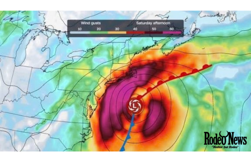
The Northeast nor’easter is unleashing a dangerous combination of heavy rain, powerful winds, coastal flooding and massive waves across the East Coast, with New York, New Jersey and parts of New England facing some of the most serious conditions.
The powerful autumn storm has already flooded roads and homes, knocked out electricity for tens of thousands of customers and produced wind gusts reaching 74 mph. Officials are warning residents in vulnerable coastal communities to avoid unnecessary travel, move vehicles to higher ground and prepare for additional flooding during successive high-tide cycles.
The storm is particularly concerning because it is moving slowly while strong winds continue pushing ocean water toward the coastline. That combination allows flooding to build over multiple tides instead of ending after a single round of bad weather.
FOX Weather reported that the storm was affecting more than 40 million Americans, while other coverage indicated that the broader threat extended across a large portion of the Atlantic coast.
1. Northeast Nor’easter Creates Major Coastal Flooding
Coastal flooding is one of the biggest threats from the Northeast nor’easter.
Strong northeasterly winds are pushing seawater toward the shoreline while large waves and storm surge add more water on top of already elevated tides. The danger is amplified by the full Harvest Moon, which produced a spring-tide cycle with higher-than-normal high tides.
FOX Weather reported that the full moon peaked Saturday afternoon, while successive high tides continued to create dangerous conditions along the coast.
Areas from the Outer Banks to New England are facing the threat.
In New Jersey, floodwaters already covered residential streets in Ocean City, while flooding forced authorities to restrict access to Long Beach Island. Route 72 was closed because of significant flooding, according to FOX Weather’s live coverage.
The Jersey Shore also saw emergency responders using specialized equipment to navigate flooded areas.
A hovercraft was deployed on Long Beach Island because conventional vehicles can struggle to move through water-covered roads, mud and debris.
2. New York Faces Another Round of Dangerous Flooding
New York is among the areas under particularly close watch as the storm continues northward.
Coastal sections of New York City, Long Island and southern Queens face the possibility of serious inundation as high tides combine with persistent onshore winds.
FOX Weather reported that officials were warning residents in low-lying areas about potentially severe flooding, while New York Gov. Kathy Hochul urged residents to take the storm seriously and warned that more impacts were coming.
The timing of the tides is crucial.
After an earlier low-tide period provided a temporary reduction in coastal flooding, water levels began rising again ahead of another round of high tides. FOX Weather reported that high tides were expected during the evening along parts of Long Island and later around Long Island Sound and coastal Massachusetts.
That means communities that experienced temporary relief could face renewed flooding as the water rises again.
For residents near tidal waterways, the risk is not limited to beaches. Water can move into back bays, streets and low-lying neighborhoods, making roads dangerous or impossible to cross.
3. Winds Reach 74 MPH as Trees and Power Lines Come Down
The Northeast nor’easter is also delivering powerful winds capable of causing significant damage.
FOX Weather reported a 74-mph wind gust in Surf City, New Jersey. Other top gusts included 70 mph at Wellfleet, Massachusetts, 70 mph at Barnegat Light, New Jersey, 69 mph at Harvey Cedars, New Jersey, and 65 mph at Stony Brook, New York.
These winds can turn trees, branches and other unsecured objects into serious hazards.
Long Island was also experiencing damaging winds, with a 55-mph gust recorded at John F. Kennedy International Airport. Officials warned that stronger gusts could bring down trees and power lines, increasing the risk of additional outages.
The storm has already demonstrated that danger.
In Brooklyn, a 56-year-old man died after being struck by a falling tree during the storm, according to the New York Police Department as reported by FOX Weather.
The incident highlights how dangerous conditions can remain even away from the immediate shoreline.
Residents should therefore avoid parking under large trees, stay away from downed power lines and follow local emergency instructions.
4. Tens of Thousands Lose Power Across the Northeast
Strong winds have also disrupted electricity service across several states.
At one point Saturday evening, nearly 70,000 customers were without power across New York, Connecticut, New Jersey, Massachusetts and Rhode Island, according to outage data cited by FOX Weather. New York had more than 27,000 reported outages, while Connecticut had more than 17,000 and New Jersey had more than 16,000.
Earlier in the day, the number of outages had climbed much higher.
FOX Weather reported that nearly 150,000 customers were without electricity during the afternoon, including roughly 30,000 in New York, 23,000 in Connecticut and 20,000 in New Jersey.
The numbers can change rapidly as crews restore electricity and additional trees or power lines come down.
The risk is especially serious in areas where winds remain strong for many hours. A prolonged storm can produce repeated damage, making restoration more difficult.
Residents experiencing outages should follow local utility instructions, conserve battery power and avoid using generators indoors or near windows because of the risk of carbon monoxide poisoning.
5. The Storm Is Disrupting Roads, Ferries and Coastal Communities
Transportation has become another major casualty of the storm.
Flooded roads are already making travel dangerous along parts of the Jersey Shore and Long Island. Officials have urged motorists to stay away from flooded areas rather than attempting to drive through standing water.
The problem extends beyond the Northeast’s major metropolitan areas.
On Hatteras Island in North Carolina, ocean overwash severely damaged N.C. Highway 12. Dare County declared a state of emergency after road access was cut off between key points on the island. Officials said there was no road access to or from Hatteras Island at the time of the declaration.
Emergency officials were also working on plans for temporary ferry service for people stranded on the island.
Meanwhile, ferry services around Cape Cod were suspended because of high winds and dangerously rough seas. FOX Weather reported that peak gusts across Cape Cod and nearby islands could reach 60 to 65 mph.
The disruptions demonstrate how the storm’s effects can spread far beyond areas directly hit by flooding.
Why This Northeast Nor’easter Is So Dangerous
Nor’easters are not unusual along the U.S. East Coast, particularly during the colder months.
What makes this storm especially concerning is the combination of several hazards occurring simultaneously.
First, the storm is slow-moving. That allows strong winds to continue pushing water toward the coastline for an extended period.
Second, the storm coincides with an enhanced tidal cycle. Higher astronomical tides give storm surge and waves a higher starting point.
Third, the storm is affecting a heavily populated stretch of coastline. From the Carolinas through New York and New England, millions of people live in areas that can be affected by coastal flooding.
FOX Weather analysis said the storm’s persistent circulation could maintain strong onshore winds across a large section of coastline and create prolonged inundation through multiple high-tide cycles.
That prolonged nature is important.
A short burst of extreme weather can cause damage, but a storm that repeatedly floods the same locations can make recovery considerably harder.
New Jersey Shore Sees Severe Flooding
New Jersey’s coastal communities have been among the hardest hit.
Ocean City experienced flooded residential streets, while other areas saw roads become impassable. Flooding along the Jersey Shore was severe enough for emergency teams to deploy specialized rescue equipment.
Coastal erosion is another major concern.
FOX Weather reported significant erosion in Cape May as powerful waves repeatedly struck the coastline. The Outer Banks of North Carolina also experienced intense beach erosion and flooding, demonstrating that the storm’s coastal impact stretches hundreds of miles.
The combination of high waves, storm surge and strong winds can rapidly reshape beaches and damage dunes.
That can leave communities more exposed to subsequent storms.
Massachusetts and Rhode Island Face Flash-Flood Threat
The storm is not only a coastal problem.
Heavy rainfall has created a flash-flood threat in parts of southeastern New England. FOX Weather reported that the first Flash Flood Warning associated with the storm was issued for parts of Massachusetts and Rhode Island.
Between 1 and 1.5 inches of rain had already fallen in the warned area, while rainfall rates of 1 to 2 inches per hour were possible. An additional 1 to 3 inches of rain was also possible.
That type of rainfall can quickly overwhelm drainage systems, particularly when high tides prevent stormwater from draining efficiently toward the ocean.
As a result, some communities could experience both rainfall flooding and coastal flooding at the same time.
What Residents Should Do as the Storm Continues
People living in coastal or flood-prone areas should continue monitoring official warnings as conditions change.
Residents should avoid driving through flooded roads. Even shallow-looking water can conceal damaged pavement, debris or deeper sections of roadway.
People should also move vehicles to higher ground before flooding begins rather than waiting until water reaches streets.
Those living near the coast should be prepared to evacuate if local authorities issue an order. Residents should keep essential medications, identification documents, phones, chargers and emergency supplies ready in case leaving becomes necessary.
During periods of strong wind, people should stay indoors and away from windows. Outdoor furniture, trash cans and other loose objects should be secured whenever it is safe to do so.
Downed power lines should always be treated as live.
More Dangerous Conditions Could Still Develop
The biggest concern is that the storm’s impact is not necessarily over after the first round of flooding.
As the Northeast nor’easter continues to interact with successive high tides, coastal communities could experience repeated periods of inundation.
FOX Weather reported that some locations were expected to see their most serious conditions later Saturday night as water levels rose again.
The storm has already produced wind gusts above 70 mph, widespread power outages, flooded neighborhoods and at least one reported death in New York City. Meanwhile, major coastal roads have been closed and emergency crews have been deployed in several states.
For residents across the Northeast, the message from emergency officials remains clear: the combination of wind, rain, waves and high tides can become dangerous quickly.
The safest approach is to avoid unnecessary travel, stay informed through official weather and emergency-management channels, and take coastal flooding warnings seriously.
The Northeast nor’easter is already proving to be a major early-autumn storm, and its prolonged impact could continue to test communities from the Carolinas to New England.