
Connecticut Storm Track: 5 Key Weekend Weather Risks
Connecticut is getting a brief period of quieter weather before a powerful coastal storm moves closer to the region this weekend. The Connecticut storm track remains subject to change, but forecast guidance has increasingly pointed toward a wetter and windier stretch from Friday through Sunday.
Thursday was expected to provide relatively calm conditions compared with what is ahead. The day featured clouds, some breaks of sunshine and temperatures generally staying in the 60s. However, a persistent northeast breeze made it feel cooler, particularly along the shoreline.
By Friday, the weather pattern begins to change. Increasing clouds, stronger winds and developing rain will signal the arrival of the coastal system. Current National Weather Service guidance for Hartford calls for breezy conditions Friday, followed by a growing chance of rain Friday night.
The storm’s exact path remains one of the most important variables.
A shift farther west could bring stronger winds and heavier rainfall farther inland. A track farther offshore would concentrate more of the storm’s strongest effects near the coast.
Either way, residents should be prepared for an unsettled weekend.
Connecticut Storm Track Is Moving Closer
The biggest change in the forecast is the storm’s projected track.
Recent weather guidance has shifted the coastal system closer to Connecticut and southern New England. That change has increased concerns about rain, strong winds and coastal impacts during the weekend.
Meteorologists are watching the interaction between a strong area of high pressure to the north and a developing coastal low to the south. The resulting pressure pattern can produce persistent northeast winds across Connecticut.
Those winds matter because they can push ocean water toward the shoreline for an extended period.
The storm is expected to affect the region for more than just a few hours. Instead, Connecticut could experience a prolonged period of rain and gusty winds, with conditions potentially continuing into Sunday and early Monday.
That longer duration is particularly important for coastal communities.
1. Strong Winds Could Become a Major Concern
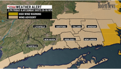
Wind is expected to be one of the main impacts associated with the weekend storm.
The National Weather Service has issued a Wind Advisory for the Hartford area from Friday afternoon into early Sunday. Its forecast calls for north winds around 15 to 20 mph Friday, with gusts potentially reaching about 31 mph.
As the storm develops, stronger gusts are possible.
Connecticut emergency management officials have been preparing for the possibility of moderate rainfall combined with winds capable of affecting infrastructure. State officials cited potential wind speeds in the 30-to-45-mph range as preparations continue.
Strong winds can create several problems.
Loose outdoor objects can become hazardous. Tree limbs may fall, especially where soils become saturated by rain. Power lines can also be affected, increasing the possibility of scattered outages.
The combination of wind and wet ground is therefore more important than either factor alone.
Residents should secure outdoor furniture, decorations, trash containers and other objects before conditions deteriorate.
2. Heavy Rain Could Continue Into Sunday
Rain is another major part of the weekend forecast.
For Hartford, the National Weather Service expects rain to become likely Friday night, with the probability increasing substantially into Saturday and Sunday. The forecast calls for rain Saturday night and Sunday, with Sunday carrying a 100% chance of precipitation in the current outlook.
That means outdoor plans could face repeated disruptions.
The exact rainfall total will depend heavily on the storm’s final track. A farther-west path could bring more significant rainfall to inland Connecticut, while a track farther east would limit some of the heavier precipitation away from the interior.
Current regional forecasts have suggested the potential for around 1 to 2 inches of rainfall, with locally higher amounts possible if the storm shifts farther inland.
The timing is also important.
Rain may begin to increase late Friday or Friday night before becoming more persistent Saturday. The storm could then maintain wet conditions through Sunday.
Because the system may linger near the region, residents should not assume that improving conditions will arrive immediately after the heaviest rain.
3. Coastal Flooding Risk Is Increasing
The Connecticut shoreline faces an additional threat that inland communities do not experience to the same degree: coastal flooding.
Persistent northeast winds can push water toward the coast. When that occurs during high tide, water levels can rise enough to flood vulnerable roads and low-lying areas.
Forecast discussions have highlighted increasing coastal concerns as the storm approaches. High surf, beach erosion and coastal flooding are possible, particularly during successive high-tide cycles.
The timing of the tides will be important.
The weekend also coincides with a full moon, which can contribute to higher-than-usual astronomical tides. When elevated tides combine with strong onshore winds and waves, coastal communities can experience flooding even without an exceptionally large rainfall total.
For shoreline residents, this means the storm cannot be judged by rainfall alone.
A location may receive moderate rain but still experience significant coastal problems because of wind direction, wave action and tide levels.
4. Dangerous Surf and Beach Conditions Are Possible
The ocean will become increasingly rough as northeast winds strengthen.
That creates hazards for anyone planning to visit beaches, piers, rocky shorelines or other exposed coastal locations.
High surf can produce powerful waves capable of sweeping people from rocks or jetties. Rip currents can also become stronger and more dangerous as waves increase.
Weather experts are warning that dangerous surf and rip-current conditions could persist along parts of the Connecticut shoreline during the storm.
Even when skies are relatively calm inland, coastal conditions can be significantly worse.
Residents and visitors should therefore avoid assuming that a lack of heavy rain automatically means the shoreline is safe.
Beach erosion is another concern.
Repeated waves combined with elevated water levels can remove sand and reshape beaches. Low-lying coastal infrastructure can also be exposed to repeated waves and flooding.
5. The Storm Could Linger Into Early Next Week
The weekend storm may not disappear quickly.
Current forecasts show additional showers possible Monday, with conditions gradually improving afterward. For Hartford, the National Weather Service currently forecasts a chance of showers Monday before a return toward partly sunny weather Tuesday.
That extended timeline means the weekend system could produce a prolonged period of unsettled weather rather than a single burst of rain.
For residents, the practical effect could include wet roads, strong winds, reduced visibility and occasional disruptions lasting several days.
The storm’s final movement will determine how quickly Connecticut returns to quieter conditions.
Connecticut Forecast: What to Expect by Day
Friday: Clouds and Increasing Wind
Friday should begin relatively manageable, but conditions are expected to deteriorate as the day progresses.
Hartford’s forecast calls for temperatures reaching around 68 degrees, with north winds of 15 to 20 mph and gusts potentially reaching 31 mph. Clouds are expected to increase, followed by a growing chance of rain Friday night.
The shoreline may experience stronger effects because of its proximity to the developing coastal system.
Saturday: Rain and Stronger Storm Impacts
Saturday is expected to be increasingly wet and windy.
The storm’s proximity to Connecticut will determine how intense conditions become. Coastal locations may experience stronger winds, higher waves and greater flooding concerns, while inland areas could see periods of steady rain and gusty conditions.
The storm’s track will continue to be monitored closely because even a relatively small shift could change the distribution of the heaviest rain and strongest winds.
Sunday: Wet and Windy Conditions Continue
Sunday could remain unsettled.
The current Hartford forecast calls for rain, temperatures around 61 degrees and north winds of 15 to 18 mph, with gusts reaching approximately 39 mph.
That combination would make Sunday a poor day for many outdoor activities.
The rain may also continue into Sunday night, although showers could become more intermittent.
Monday: Gradual Improvement
Monday may bring the first signs of improvement, although the storm’s influence could linger.
The National Weather Service forecast includes showers, particularly during the morning, followed by mostly cloudy conditions. Winds should gradually weaken compared with the weekend.
A more meaningful return to quieter weather is expected later.
Why the Connecticut Storm Track Matters
The phrase “storm track” is more than a technical weather term.
For Connecticut, the storm’s exact position could determine whether communities experience mainly rain and breezy conditions or a more disruptive combination of heavy rain, stronger wind and coastal flooding.
A westward shift generally increases the potential for stronger impacts farther inland.
An offshore track can keep some of the worst conditions away from Connecticut while still producing significant coastal effects.
That is why forecasters are continuing to update their projections rather than treating the current forecast as final.
Weather models become more useful as the storm approaches and observations provide additional information about its structure and movement.
Residents Should Prepare Before the Storm Arrives
Connecticut officials are already encouraging residents and communities to prepare for possible weekend impacts. State emergency management officials have been coordinating with municipalities and utilities as forecasts become clearer.
Residents can take several simple steps before the weather worsens.
Secure objects that could be blown around by strong winds. Charge phones and other essential devices. Check flashlights and batteries. Keep vehicles away from locations that could flood.
Coastal residents should also monitor tide forecasts and local advisories.
Anyone living near rivers, streams or low-lying areas should pay attention to rainfall forecasts and changing water levels.
Most importantly, residents should continue monitoring official forecasts because the Connecticut storm track remains subject to change.
What Comes Next for Connecticut Weather
The immediate forecast points toward a clear transition from a relatively quiet day to a much more unsettled weekend.
Thursday offered a brief break, with cool temperatures and limited rainfall. By Friday, winds and clouds were expected to increase. Rain then becomes a bigger factor Friday night through Sunday, while coastal communities face additional risks from waves, erosion and flooding.
The most important uncertainty remains the storm’s exact path.
Forecasters have increasing confidence that Connecticut will feel the system’s effects, but the precise location of the strongest winds and heaviest rain can still change.
That uncertainty is particularly important for coastal communities.
For now, residents should treat the weekend as a period of potentially disruptive weather rather than a single short-lived storm.
The Connecticut storm track will continue to evolve as the system approaches, and each forecast update should provide a clearer picture of what residents can expect.
For the latest official information, residents should monitor the National Weather Service and local emergency management agencies.